몰몬경, 지리상의 이해 존 피 프랫 (번역 정민호) 여러분은 몰몬경의 상세 지도가 있었으면 하고 항상 생각하지 아니했는가? 여러분이 성경을 읽을 때는 지도를 펴 여러 사건이 실제로 일어난 곳을 찾아볼 수 있으며 그 대부분의 지역을 오늘날 방문할 수 있다. 우리가 몰몬경을 읽을 때 그 활동 전개를 지도상으로 따라 갈 수 있다면 얼마나 좋겠는가! 불행히도 지금까지 우리는 맨타이 땅이 어디며 시돈강은 또 어디인가를 분명하게 지적해 주는 상세지도를 가지고 있지 않다. 몰몬경을 연구하는 학자들에 의하여 대강의 지역을 보여주는 지도는 가지고 있으나 정확성이 결여된 것이다. 그러나 이제 비로소 그러한 요구에 부응하는 지도가 가능하게 되었다. 본 아리클은 몰몬경의 원문에서 하나하나 대조한 76개의 상세 아이템을 제기하는 하나의 지도를 자세하게 검토하고 있다. 그것은 시각적인 설명으로 된 소책자로 <몰몬경, 중미의 역사적 지리>. 라는 책이다. 이 소책자는 크리스마스에 즈음하여 온라인으로 가능할 것이다. 이것은 고고학자인 V Garth Normon에 의하여 40년에 걸친 연구로 출현하게 되었다. 저자는 고고학과 고대의 경전 두 분야에서 고급 학위를 받은 바 있다. 이 책은 탁월한 안목을 보여주고 있으니 이제는 몰몬경의 지리가 떠오르는 새로운 시대와 같아 보인다. 먼저 대부분의 학자들이 제시한 지도상의 주요 포인트를 간단히 살펴보고 노만의 뛰어난 발상이 가져다주는 가능한 해결책을 발견하여 지금까지 모호하던 점에 초점을 맞추어 보자. | Mormon's Map Puzzle Solved? by John P. Pratt Haven't you always wanted to have a detailed map of just where everything is in the book of Mormon? After all, when you read the Bible, you can turn to the maps and see where everything happened. In fact, you can go and visit most of those places today. Wouldn't it be wonderful to have maps in the Book of Mormon where we could follow the action as we read? Unfortunately, we have never had a detailed map where we can point with confidence to just where the land of Manti or the River Sidon was. We have had maps made by a variety of Book of Mormon scholars that showed general areas, but with very few precise locations pinpointed. Now such a map is available. This article reviews a new map that proposes some 76 detailed items, complete with Book of Mormon textual references for each. It comes with an optional explanatory booklet entitled Book of Mormon - Mesoamerican Historic Geography, and is available online in time for Christmas.[1] It was produced after forty years of research by archaeologist V. Garth Norman, who has advanced degrees in both archaeology and ancient scripture, and it looks excellent. It appears that a new day in Book of Mormon geography may be dawning. Let us review briefly some of the key anchor points used by most scholars for their proposed maps, and then focus on one particular puzzle that Norman has found a brilliantly creative possible solution for. |
지도상의 닻 우리는 몰몬경에 기록된 역사가 전개된 곳이 어느 곳인가를 발견하기 위하여 어떻게 자료를 찿아 볼 수 있는가? 그 하나의 방법은 점진적인 방법이니 하나하나의 주춧돌을 놓아 건물의 확실한 기초를 닦는 것과 같다. 첫째로 몇 개의 견고한 모퉁이 돌을 놓아, 주요 기본 포인트를 잡고 그와 관련된 더 많은 포인트를 채워 넣는 것이다. 그런 다음 최종적인 모든 상세 내용을 집어넣는 것이다. 마치 퍼즐을 맞추는 것과 같다. 그러면 어떻게 시작할 것인가? 하나의 신뢰할만한 방법은 네 모퉁이의 조각을 먼저 찾아낸 후 네 개의 가장자리 윤곽을 완성한다. 그 다음 그것을 근거로 하나하나의 조각을 채워 넣어 퍼즐을 완성하는 것이다. 나의 연구과정에서 종교적인 연표를 결정할 때도 이와 같이 행한다. 첫째 그리스도의 부활과 예루살렘성의 함락등과 같은 고정된 주요 포인트를 결정한 다음 그것으로부터 더 많은 주요 포인트를 찾아내어 연결시키는 것이다. | Map Anchors How can one go about discovering where it was in the Americas that the history recorded in the Book of Mormon took place? one way is a step-by-step "anchoring" method where one builds stone by stone on a firm foundation. First one lays some solid cornerstones that are key anchor points, fills in more points that are known relative to them, and then all of the final details. It is like putting together a jig-saw puzzle. How does one start? one reliable method is to find the four corner pieces first, then complete the four borders, and then build in from there to complete the puzzle. In my work to determine religious chronology I did likewise, first determining fixed anchor points such as the date of the resurrection of Christ and fall of Jerusalem, and then reckoning from there to get more anchor points. |
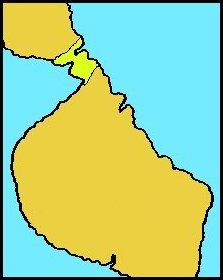
제한된 지리상의 영역 몰몬경 내부의 지리상의 거리는 수일간의 여행이라는 조건으로 나타나 있다. 많은 성읍들이 자체의 이름으로 언급되어 있으며 다른 성읍들과 대강의 방향관계를 나타내고 있는 경우도 있다. 최남단에서 최북단까지 여행할 경우 수 주일간의 거리로 (모사이야 23:3, 20, 25). 이것은 전체 영역이 수백 마일에 불과하다는 것이다.
Figure 1. A land nearly | Limited Extent Distances in the Book of Mormon are given in terms of days of travel. Moreover, many named cities are mentioned, sometimes with their approximate directional relationship to others. When one looks at the time stated to travel all the way from the southernmost part to the north, it is only a matter of weeks (Mosiah 23:3, 20,25), which implies that the greatest dimension of the entire area is only a few hundred miles. |
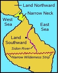
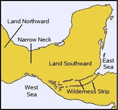
좁은 지협 몰몬경의 지리에 대한 전체적인 서술을 가장 잘 요약한 것은 몇 가지 전쟁의 세부상황을 기술하기 위하여 몰몬 자신이 기록한 것이다. (앨마 22:27-34). 그가 언급한 한 가지 뚜렷한 특징은 좁은 지협으로 분리된 북쪽의 땅과 남쪽의 땅이 있다는 사실이다. 그러므로 우리는 지협에 의하여 분리된 두 땅을 바라보는 것이다. 서반구에는 그러한 장소가 여럿 있어 우리는 더 많은 실마리를 찾아볼 필요가 있다. | Narrow Neck of Land The best summary of the overall description of Book of Mormon geography is given by Mormon himself in preparation for describing some detailed wars (Alma 22:27-34). one very distinctive feature he mentions is that there was a Land Northward and a Land Southward separated by a narrow neck of land Thus, we are looking for two lands separated by an isthmus. There are many of such places in the western hemisphere, so we need to look for more clues. |
거의 물로 둘러싸인 땅 몰몬이 제시하고 있는 또 하나의 커다란 실마리는 남쪽 땅은 거의 물로 둘러 싸여 있다는 것이다 (앨 22:32). 그것은 동 서 남북으로 각각 바다에 이르기 까지였더라 (힐 3:8). 이와 같은 이유로 리하이의 일단으로 처음 이 땅에 도착했던 몇몇 사람들은 자기들이 섬에 살고 있다고 믿었음에 틀림없다. (니이 10: 20)
Figure 2. Location of | Nearly Surrounded by Water Another huge clue provided by Mormon is that the Land Southward was "nearly surrounded by water" (Alma 22:32). It had seas to the east, south, west and north (Helaman 3:8). No doubt it was for that reason that some of the first who arrived with Lehi's group believed that they were on an island (2 Nephi 10:20). Now this added information really limits possibilities, even without archaeological finds. Figure 1 shows a map drawn by J. N. Washburn in 1968 showing these two key features, without attempting to refer to any specific known location.[2
|
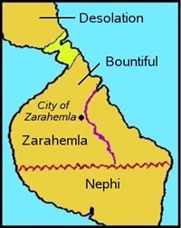
진보된 두 문명 몰몬경은 동반구에서 서반구로 서로 다른 시간대와 장소로 이주한 두 주요 집단을 기술하고 있다. 그 첫 번째 집단은 바벨탑(약 2000 BC) 으로부터 대륙중의 바다를 (카스피 해로 추정) 건너고 여행을 계속하여 (중국으로 추정) 큰 물(태평양) 을 횡단하여 좁은 지협의 북쪽 땅에 상륙하게 되었다. 또 하나의 다른 집단은 (리하이와 물렉의 분리된 이주를 포함한) B.C 600년경에 예루살렘으로부터 왔다. 우리는 리하이의 경로는 기본적으로 아라비아반도를 횡단한 다음 태평양을 건너고 서반구 어느 지역의 남쪽 땅에 상륙한 것으로 되어있다. 몰몬경에 기술되어있는 대부분의 기간 동안 리하이의 후손들(니파이인과 레이맨인)과 물렉인들은 남쪽 땅에 살고 있었다. B.C 약 400-200의 기간 동안에 그들은 세 개의 특정지역에 살고 있었으니 물렉인은 리하이가 처음 상륙한 땅의 최북단에 니파이는 중부에 레이맨인은 그 남쪽 땅에 거주하였다. B.C 300-200경, 야렛백성들은 큰 내란에 휘말려 그 문명 대부분이 파괴되었다. A.D 400년경에는 레이맨인들이 그 동일한 지역에 체재하던 물렉인과 니파이인들을 멸망시켰다. 그림 2는 왓쉬번의 지도상에 그 대강을 보여주고 있다.
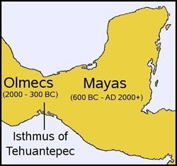
여기에 고고학이란 과학이 좁은 지협을 찾아내가 위한 커다란 실마리를 제시하여 주고 있으니 그것은 우리가 두 문명을 분리시키고 있는 하나의 지협을 찾고 있다는 것과 그들이 거주하였던 기간을 알고 있기 때문이다. 이러한 정보에 따라 뚜렷한 선두주자로 두드러진 하나의 지협은 멕시코의 Tehuantepec 지협인 것이다. 바로 좁은 지협의 북쪽 땅에는 B.C 2000-300경에 Olmecs가 살았으며 그 남쪽에는 B.C 600년경부터 현재까지 마야인들이 살고 있다. 그 위에 남쪽 땅은 거의 물로 둘러싸여 있다. 그러한 점은 시간과 공간상에 완전하게 일치하는 것이다. (그림 3 참조). 이러한 일치성은 1946-1960의 BYU 고고학부의 First Head였던 M. Wells Jackman에 의하여 처음 강조된 바 있다.
이 지역은 그림 4에서 볼 수 있듯이 멕시코 남부, 과데말라 벨리즈 혼두라스 엘살바도르 및 니콰라과의 일부를 이루는 중앙아메리카의 북부 여러 나라를 포함하는 것이다. | Two Advanced Cultures The Book of Mormon describes two main groups who migrated from the Eastern Hemisphere to the Western at very different times to different places. The first group left from the Tower of Babel (about 2000 BC), migrated north, crossed an inland sea (most likely Caspian Sea), continued on (most likely to China), and then crossed the great waters (Pacific) to come inhabit the Land Northward of the Narrow Neck. The other group (consisting of both Lehi's and Mulek's separate migrations) came from Jerusalem about 600 BC. We are only told that Lehi's route was basically to cross Arabia and then the Pacific to land in the Land Southward. During most of the period described in the book of Mormon, both Lehi's descendants (the Nephites and Lamanites) and also the Mulekites lived in the Land Southward. For the period of about 400-200 BC they were in three distinct areas of that land, with the Mulekites northernmost, the Nephites in the Middle, and the Lamanites in the southern part, where Lehi first landed. Around 300-200 BC the Jaredites had a huge internal civil war in which that civilization was largely destroyed. Around AD 400 the Lamanites destroyed the Mulekites and Nephites who had stayed in that area. Figure 2 shows the approximate arrangement on Washburn's map. Here is where the science of archaeology provides a great clue to locate the Narrow Neck because we know we are looking for an isthmus separating two civilizations and we know the time periods in which they existed. Given this information, there is one isthmus which jumps out as being the clear front runner. It is the Isthmus of Tehuantepec in Mexico. Just northward of that Narrow Neck lived the Olmecs from about 2000 - 300 BC and south of it lived the Mayans from about 600 BC until the present day. Moreover, the land southward is nearly surrounded by water. That is a perfect match of time and place (see Figure 3). This identification was first emphasized by M. Wells Jakeman, first head of the BYU Department of Archaeology from 1946-1960. It has become known as the "Limited Tehuantepec Theory."[3] Today, nearly all researchers agree with this identification. This area comprises the southern part of Mexico and the northern countries of Central America of Guatemala, Belize, Honduras, El Salvador and part of Nicaragua as shown in Figure 4. |
좁은 광야의 Strip(좁고 긴 땅,즉 대역) 이제 우리는 몰몬경 학자들 간에 견해의 불일치가 다소 심한 하나의 중요한 특징을 찾아보고자 한다. 그 가장 중요한 것은 아마도 동해로부터 서해(앨마 22:27)로, 즉 대서양에서 태평양을 이어주는 광야의 좁은 Strip대역(帶域)의 위치일 것이다. B.C 100년경에 이 대역(帶域)은 그 남쪽에 거주하는 레이맨인으로부터 북쪽의 니파이인과 뮬레크인을 분리시켜 주었다. 이것은 레이맨인들이 니파이인들의 땅을 정벌하지 못하도록 하기 위하여 니파이인들이 남쪽 국경을 폐쇄시키는 것은 전술적으로 중요한 것이었다. 모로나이 대장은 이러한 목적을 위하여 이 Strip을 따라 7개의 성읍을 요새화하였다. 이 기다란 띠로 된 땅, 즉 그 대역(帶域)이 니파이인들에게 군사상 전술적으로 중요하였던 것은 오늘날 우리에게 다행인 것이었으니 그 중요성의 한 실마리가 몰몬경의 기록에 포함된 원인이 되었기 때문이다. 광야의 상태는 어떠하였는가? 그것은 다만 사람이 살지 아니한 정글지역을 지칭할 뿐인가? 하나의 실마리는 모로나이가 여러 성읍을 보호하기 위하여 그 대역상의 여러 특정지역에 위치한 성읍들을 강화해야만 했던 것이다. 그러므로 다른 지역들을 통하여 국경을 넘어가기는 어려움이 있었음에 틀림없다.
| Narrow Wilderness Strip Now we begin to look at important features about which there is more disagreement among Book of Mormon scholars. The most important is probably the location of a strip of wilderness which ran all the way from the East Sea to the West Sea (Alma 22:27), that is, from the Atlantic to the Pacific Ocean. At about 100 BC, this strip separated the Nephites and Mulekites on the north from the Lamanites on the south. It was important strategically for the Nephites to close off their south border to keep the Lamanites from overrunning their land. Captain Moroni had seven cities fortified along this strip for that purpose. It is fortunate for us that the strip had strategic military importance to the Nephites because that likely caused this important clue to be included in the record. What was the nature of the "wilderness"? Does that only refer to uninhabited jungle areas? one clue is that Moroni only had to fortify cities at certain locations on the strip in order to secure it, so it must have been difficult to cross at other places. Before looking for it, let us look at one more clue. |
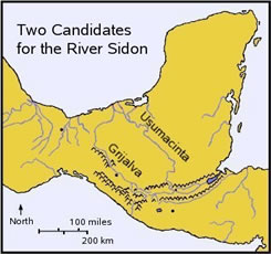
시돈강 몰몬경에 기록되어 있는 유일한 강은 시돈강이다. 이것은 하나의 큰 전쟁 이후 수천의 시체를 던져 넣고 또 그것을 바다로 쉽사리 쓸어가 버릴 만큼 충분히 큰 강이었다. 시돈강은 니파이와 물렉인들이 문명사회를 이룩한 후 수도로 삼았던 제이라헤믈라라는 큰 성읍이 바로 시돈강 서편에 위치하고 있었다는 그 자체로써 그 역사적 중요성을 가지고 있다. 하나의 중요한 지리적 실마리는 시돈강의 발원이 광야의 산맥줄기에 위치하여 있었다는 사실이다 (앨마 22:29). 이것은 두 가지 사실을 우리에게 말해 주고 있다. 첫째, 산들이 시돈강이 발원하는 곳이었음으로 그 광야의 대역이 산악으로 이루어진 지역이었다는 것이다. 둘째, 만약 기록되어 있는 바와 같이 산맥이 동에서 서쪽으로 걸쳐있는 것이라면 적어도 시돈강의 일부는 산악지대로부터 북쪽으로 흐른다는 것이다. 대서양에서 태평양까지 줄곧 이어주는 하나의 산맥을 찾아볼 수 있는 곳은 서반구에서는 그리 흔하지 않다. 주요 산맥들은 북에서 남으로 내달리는 경향이 있다. 이 특징은 대단히 뚜렷하여 특정 위치를 추정하는 첫째가는 표준으로 삼아도 손색이 없다.
Figure 6.
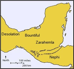
Figure 7. 그 지역에 대한 몰몬의 기록에는 지도상의 대 지구 이름을 제시하여 주고 있다. 좁은 지협 가까이 있는 북쪽 땅을 데솔레이션이라 했으며 바운티풀은 바로 그 남쪽에 위치한다. (앨마 22:30-31). 다시 그 남쪽에는 제이라헤믈라 땅이니 이는 광야의 대역으로 멀리 남쪽에 위치한 나파이 땅으로부터 분리되어 있다. (앨마 22:34). 이들 지구는 그림 7과 8에 나타나 있다. 이제 퍼즐로 돌아가자.
Figure 8. | River Sidon The only river described in the Book of Mormon is the River Sidon. It was a large enough river to throw thousands of corpses in after a battle and have them easily wash out to the sea. It is important in the history because the great city of Zarahemla, the capital of the Nephite/Mulekite civilization after they merged, was just west of the Sidon. An important geographical clue is that the head waters of the Sidon were located at the Wilderness Strip (Alma 22:29). That tells us two things. First, that area of the strip is mountainous, because mountains are where rivers begin. Secondly, if the strip is east-west as described, then at least part of the Sidon flows north, away from the mountains. Figure 5 shows Washburn's placement of the river, along with my addition of the wilderness strip and the city of Zarahemla.
When we look at the proposed location we find not one but two possible mountain ranges that run nearly continuously from ocean to ocean, as shown in Figure 6. Some researchers favor one range and some the other, and some both together forming the strip.[4]
|
림하이의 탐험 시돈강을 찾아 보기 전에 , 두 번째 중요한 경계표를 확인하기 위해서 노만의 지도와 주석서가 해결한 것 같아 보이는 하나의 "퍼즐"에 눈길을 돌려보자. 사실 몰몬경의 지리에는 수수께끼 같은 문제가 되는 국면이 많이 있다. 그러나 나에게 있어서는, 제시되어 있는 하나의 지도가 올바른 것일 수 있는 가능성을 가지고 있느냐, 아니냐 하는 것을 결정하기 위해서는 "리트머스시험"이 있다. 나는 이것을 형식상의 논리적 퍼즐이라 부르고 싶다. 이것은 여러분이 Norman의 해법을 읽기 전에, 지금 스스로 풀어 보려 시도해 볼 수 있다. 그 퍼즐이란 림하이 탐험대(모사이야 8:7-11, 21:25-26참조)가 경험한 이상야릇한 결과를 따라 설명하기 위한 방법으로, 몰몬경 내부의 지도(그림 7, 또는 여러분 자신의 지도와 같은)상에서 제이라헤믈라성은 물론 시돈강을 이끌어 내는 것이다. 나에게 있어서 이 기록은 어떤 지도상에서도 아주 설명해 내기 어려운 내용이다. 그러므로 실제의 지도상에서 하나의 해법을 발견한다면 그 강과 성읍의 존재가 옳다는 사실은 물론, 몰몬경이 참된 기록이라는 강력한 증거가 될것이다. 이것은 엄밀하게 퍼즐로서 실행되어야 한다. 물론 어떠한 실제 해법도 몰몬경의 기사로부터 모든 다른 내부적 세부사항과 고고학적 발견과 서로 상관관계가 필요하다. | Limhi's Expedition Before looking for the River Sidon, the next important landmark to identify, let us turn to one "puzzle" which the Norman map and explanatory booklet appears to solve. There are actually many puzzling aspects of Book of Mormon geography, but there is one which has been a "litmus test" for me in deciding whether or not a proposed map has a chance of being correct. Allow me to state it as a formal logic puzzle, which you may now try to solve yourself before reading Norman's solution. The puzzle is to draw the River Sidon, as well as the location of the city of Zarahemla, on a Book of Mormon internal map (such as in Figure 7, or your own), in a way to explain the following weird result of the "Limhi expedition" (see Mosiah 8:7-11, 21:25-26). To me this account is difficult to explain on any map at all, so finding a solution on a real map would be compelling evidence both for the Book of Mormon being a true record, as well as the river and city being correct. This is to be done strictly as a puzzle; of course any real solution would need to correlate with archaeological finds and all the other internal details from the Book of Mormon account. Now consider the details of the puzzle that you need explain. |
퍼즐 니파이땅이라 불리는 남쪽땅의 남부에 살고 있던 림하이라 하는 왕이 살고 있었다. 그의 성읍은 적 레이맨인의 속박가운데 있었으니, 그는 그의 할아버지 일행이 떠나온 큰성 제이라헤믈라에 도움을 청하고자 일단의 탐험대를 파송하였다. 그 성읍은 시돈강의 바로 서쪽에 위치하고 있었으며 그 강의 원천이 그들의 북쪽 그리 멀지 아니한 곳인 광야의 대역에서 발원하고 있다고 알려져 있었다. 비록 이 새로운 세대는 제이라헤믈라에 가본 적이 결코 없었으나 자기들이 가진 정보와 그곳에 가는데 필요한 대강의 기간을 따른다면 그곳을 발견하기는 그렇게 어렵지 않으리라 희망적으로 생각하고 있었다. 그러나 실제 어떠한 일이 일어났는가 하는 문제는 참으로 미스테리 같아 보인다. 그 탐험대는 길을 잃고 (정글 지역에서 흔이 있을 수 있는) 급기야 많은 물이 있는 땅과 하나의 성읍을 발견하고 참으로 제이라헤믈라라고 생각하였다(모사이야 21:26). 그러나 어찌하랴, 그 성읍은 오래전에 파멸된 곳이었으니 그들은 다만 마른 뼈와 녹슨 칼과 갑옷을 발견하였을 뿐이었다. 그들은 제이라헤믈라를 발견하였다는 강한 확신과 그 나쁜 소식을 가지고 림하이 왕에게 되돌아갔다. 귀향길에 헤매었다는 어떤 이야기도 없으니 필시 아무런 어려움 없이 되돌아 온 것 같다. 이제 퍼즐 부분으로 되돌아 가, 그들이 발견한 파괴된 성읍은 후일 데솔레이션이라 하는 북쪽땅의 일부인 좁은 지협이 있는 땅이거나 그 넘어 위치하고 있었다. 이 데솔레이션은 그림 7에서 보는 바와 같이 좁은 지협(앨마 22:30-32)의 남쪽땅에 있는 바운티풀로부터 분리되어 있었다. 그 퍼즐은 탐험대의 여정을 그려주고 이들 훈련받은 일단의 탐험대가 어찌하여 파멸된 성읍을 제이라헤믈라로 오인할 수 있었는가를 설명하여 주고 있다. 그 해답은 다음 문제를 포함해야 한다. 1) 그들이 찾아 나선 것에 대하여 가지고 있음직한 정보. 2) 그것을 발견하기 위한 그들의 계획. 3) 많은 물이 있는 땅과 왜 그것이 포함되어 있는가 하는 문제. 4) 그 파괴된 성읍이 왜 그들이 찾던 성읍이라 믿었는가 하는 신뢰성. 5) 왜 그들은 그것이 제이라헤믈라가 아니라는 사실을 알지 못했는가. 6) 그들의 귀로는? 퍼즐 이론에서 하나의 요점을 여기에 제시하면, 몇 가지 논리적인 근거가 있다. 그것은 의식을 가진 사람들이 무었인가에 오도되어버렸다면 그것이 근거하는 실마리가 있다. 이 경우 우리는 그 탐색대가 어찌하여 파괴된 성읍이 제이라헤믈라가 아니었다는 실마리를 풀지 못하고 그대로 왕에게 돌아가 보고해야 한다고 생각한 충분한 이유를 설명해야만 한다. 그렇다면, 독자는 본문을 읽는 것을 그만두고 여러분 자신이 그 퍼즐을 풀어보자. 단순한 마음으로 어떤 지도든지 필요한 모든 요소가 들어있는 지도를 상상으로 그려본다.(그림 7과 비슷한). 그리고 그 탐험대가 이동했으리라 생각되는 가상 진로를 그려본다. 자, 여러분은 어떻게 하였는가? 여러분은 틀림없이 난관에 봉착했을 것이다. 내가 여기에 형식적인 퍼즐로써 질문을 낸 이유는 그림 7과 같은 지도를 작성하여 어떤 좋은 해결책을 유도하여 낸다는 것은 거의 불가능하기 때문이다. 아무리 본인이 니파이땅으로부터 북쪽 땅의 데솔레이션에 이르는 가상 진로를 그려봐도 그것(파괴된 성읍)은 제이라헤믈라는 아니라는 사실을 쉽사리 알 수 있었다. 그 성읍은 대양 근처에 있었으며 니파이땅으로부터 너무 멀리 있었기 때문이다. 본인이 Garth Noman의 해법을 보고서야 그 대답이 분명하여 진다는 것이다. 나에게 있어서는 그것 자체가 몰몬경에 대한 하나의 증거가 되는 것이다.
Figure 9. Two Rivers. | The Puzzle There was a king named Limhi who lived in the southern part of the Land Southward, called the Land of Nephi. His city was in bondage to the enemy Lamanites, so he sent an expedition to get help from the great city of Zarahemla from which his grandfather had come. It was known to be just west of the River Sidon, and that river was known to have its headwaters not far north of them in the Wilderness Strip. Even though this new generation might never have been there, it hopefully wouldn't be too difficult to find given that information, and the approximate length of time needed. But what happened seems mysterious indeed. The expedition got lost (not too hard in a jungle region), found a land of many waters, and a city that they thought was indeed Zarahemla (Mosiah 21:26). But alas, the city had been destroyed long enough ago that they found only dry bones and rusted swords and armor. They were so strongly convinced that they had found Zarahemla, that they returned to King Limhi with the bad news. Nothing is mentioned about getting lost on the way home, so apparently that was not a problem. Now for the puzzling part. The destroyed city they found was in, or beyond, the narrow neck of land, in the part of the Land Northward later called Desolation, which was separated from Bountiful in the Land Southward by the Narrow Neck (Alma 22:30-32), as shown in Figure 7. The puzzle is to draw their route and explain just how these trained scouts could have mistaken the destroyed city for Zarahemla. A solution must include 1) what they probably knew about what they were looking for, 2) what their plan had been to find it, 3) where the land of many waters was and why it was included, 4) how the destroyed Jaredite city would have met their criteria, 5) why at no point did they know that it was not Zarahemla, and 6) what their return route was. Just a note here from puzzle theory: there are several logic puzzles whose solution is based on the clue that an intelligent person was baffled by something.[5] In this case we must explain how the search party had no clue that it was not Zarahemla and enough reason to think that it was to return and report. Okay, time to stop reading this article and go do the puzzle yourself. Simply draw any map with all of the required elements (something like Figure 7) and draw in your proposed solution of just where the expedition might have gone. Well, how did you do? Most probably you had a difficult time. The reason I posed the question here as a formal puzzle is that it is nearly impossible to come up with any good solution using the map of Figure 7. No matter how I drew a false route from Nephi to Desolation in the Land Northward, it could easily have been known that it was not Zarahemla because it was near the ocean and way too far from the land of Nephi. It was only when I saw Garth Norman's solution that the answer became clear. To me that in itself is a witness for the Book of Mormon. That is, when allowed the latitude of drawing any map at all, one would expect the imaginary map to succeed when the real map fails. But it is the other way around.
|
해결책 제시 여기 제시하는 해결책의 첫 부분은 고대의 세계, 심지어 오늘날에도 미개발 지역에서는, 뚜렷한 길이 없는 지역을 여행하는 첫번째 법칙은 어떤 강줄기를 따른다는 점에 주목하는 것이다. 시돈강이 광야의 대역가까이서 그 원천을 두고 있다는 사실은 우리에게 말해주고 있다는 것은 그들이 받은 탐험지침에 "시동강의 원천을 찾아내어 그 강을 쭉 따라 그 강의 서쪽에 있는 큰 성읍에 도달할 때 까지 X일 동안(주어진 날자) 내려가라. 결코 놓치지 아니할 것이다" 라고 말해 주는 것 같다. 만일 이 가정이 사실이라면 그들이 혼란에 빠진 유일한 설명은 그 탐험대는 동일한 지역에 있는 또 다른 강의 원천을 따라 내려갔다는 것이다. 그것은 그들에게 정보를 남긴 선조들은 동일한 지역의 다른 강을 따라 올라 왔으므로 그들에게 알려지지 아니한 강이 있었다. 그 설명에는 보다 상세한 내용이 있으나 먼저 실제의 지도를 찾아보도록 하자.
Figure 10. 중미의 지도를 편다. 우리는 시돈강의 후보가 되기에 족한 두 개의 강을 분명하게 볼 수 있다. 그리고 그 두 강의 원천은 광야의 좁은 대역이라 상정되는 곳에 거의 서로 얽혀 있다. 그 두 강은 그림 9에 그 원천이 근접하여 나타나 있는 바와 같이 Grijalva와 Usumacinta강이라 불린다. 이 지도는 Norman의 것 보다 약간 더 자세하고 백과사전에서 여러 정보를 종합하여 내 놓은 것이다. 나에게 있어서 이것은 물몬경을 지지 하는 강력한 발견이 된다. 두 개의 유사한 강을 발견한 것에 놀라기 보다, 그 기록은 최소한 두 개의 그러한 강이 있음에 틀림없다는 것을 넌지시 예고하고 있다. 다시 우리는 서반구 어느 곳에 동서를 가로지르는 산맥가운데서 발원하여 유사한 방향으로 흘러 서로의 강이 쉽사리 혼동될 수 있는 곳이 있는가 하고 질문할 수 있다. 관련된 어느 기록을 주의 깊이 읽어도 암시적인 것이 많지만, 정규교육을 받지 못한 젊은이가 한 세기 이후에나 발견될 실제 지도상의 이상적인 해법이 될 암시적인 퍼즐을 구상할 수 있다고 믿기는 심히 어렵다. 만일 시돈강의 후보지가 단 하나만 있었다면 몰몬경상의 고고학은 지금쯤은 보다 더 진척되어 있을 것이다. 이들 각각의 강에 대한 지지자가 나뉘어 있음으로 들이는 노력 또한 양분 되어 왔다. 그러한 까닭에 우리는 제이라헤믈라가 위치한 곳이 어딘가가 확실하지 않다. 우리가 가진 모든 현대적인 기술을 가지고도 우리는 림하이의 탐험대와 거의 마찬가지로 혼동되어 왔다. M, Wells Jakeman은 Usumacinta를 선호하는데 반하여 1978-1986에 BYU 인류학부장이었던 John L Sorenson은 Grijalva를 선호하고 있으니 그곳의 고고학이 더 발달되어 있기 때문이다. 그는 Santa Rosa의 유적이 제이라헤믈라였다고 제안하여 왔다. 대부분의 학자들이 그의 주장을 따랐다. 그러나 Garth Norman 은 줄곧 Usumacinta가 과연 바른 해법이라는 주장을 견지하여 왔다. 그러나 대부분의 학자들이 동의하는 하나의 내용은 데솔레이션땅의 위치와 여러 곳의 파괴된 Olmec 성읍들이 있는 지역은 제이라헤믈라와 혼동될 가능성이 있는 것이다.
Figure 11. | The Proposed Solution The first part of the proposed solution is to note that in the ancient world, or even today in any primitive area, the first rule of traveling without a road is to follow a river. The fact that we are told that the Sidon had its headwaters near the Wilderness Strip is tantamount to saying that their instructions were something like, "Find a headwater tributary of the Sidon and simply follow it for about x (some number given) days until you come to a huge city on its west side. You can't miss it." If that were the case then about the only explanation of their confusion is that they followed the wrong river, which also had headwaters in that same area, unknown to the grandfathers giving instructions, who had come the other way. There are more details to the solution, but first let's look at a real map. Turning to the map of Mesoamerica, sure enough, we find two rivers both of which are good candidates for the River Sidon, and they both have their headwaters nearly intermingled in a pass that traverses both of the candidates for the Narrow Strip of Wilderness. Today they are called the Grijalva and Usumacinta Rivers, as illustrated in Figure 9, with the proximity of their headwaters detailed in Figure 10. This map is slightly more detailed than Norman's and was produced from combining the information from several maps from encyclopedias. To me this is a compelling find in support of the Book of Mormon. Rather than being surprised to find two similar rivers, the account tacitly predicts there must be at least two such rivers. Again we could ask, where else in the western hemisphere are there two large rivers which begin near each other in a coast-to-coast east-west mountain range, flow in similar directions through similar highland and lowland areas, and hence could easily be mistaken for each other. Much is implied in a careful reading of any account, but it is tough to believe that an unschooled youth could come up with such an implied puzzle which has an ideal solution on a real map, only to be discovered a century afterward. If there had only been one candidate for the River Sidon, Book of Mormon archaeology would probably have progressed much further by now. Because there are supporters for each of these rivers, the efforts have been divided, and hence we are unsure of just where Zarahemla was located. With all our modern technology, we have been almost as confused as Limhi's expedition. M. Wells Jakeman favored the Usumacinta River, whereas John L. Sorenson, head of the BYU Dept. of Anthropology from 1978-1986, favored the Grijalva because the archaeology is better there. He has proposed that the ruins at Santa Rosa were Zarahemla. Most researchers have followed his lead. Garth Norman, however, has maintained all along that the Usumacinta is indeed the correct solution. The one thing on which most researchers agree, however, is the location of the Land of Desolation, and the area of several destroyed Olmec cities which might have been confused with Zarahemla. The principal candidates seem to be La Venta, San Lorenzo, and Tres Zapotes. Now let us return to the puzzle, and compare each of these two proposed solutions.
|
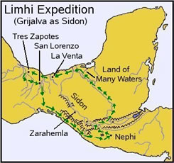
Grijalva / 시돈강 만일 제이라헤믈라가 Grijalva상의 Sata Rosa에 위치하고 있다면 그 탐색대가 1, 2주의 여행을 기대했을 것이다. 그들은 오해로 인하여 Usumacinta의 원천지류를 따르게 되어 많은 물이 있는 땅인 저지대에서 여행의 끝을 맞게 된다. 그런 다음 제이라헤믈라가 아닌, 바다를 접하게 되어 그들은 야렛인의 유적지에 부딪치게 될 때까지 한 주일동안 서쪽으로 진행하였다. 되돌아 오는 길에 그들은 Grijalva를 따라 올 수가 없었다. 또는 실제 제이라헤믈라를 발견했으며 Isthmus(좁은 지협)을 가로질러 귀향하는 다음 여정을 인식할 수 있는 서쪽 해안을 따라 남하하였을 가능성이 있을 수 있다. 또는 그들이 내려왔던 전 노정을 되돌아갔을 가능성도 있다. 그림 11은 이 시나리오를 예시하여 주고 있으니 니파이땅에서의 출발점을 보여주는 림하이의 탐색대의 노정, Usumacinta를 따른 많은 물이 있는 땅, 야렛인의 폐허를 발견함, 그리고 해안을 따른 귀향길 등 이다. 많은 학자들이 이 시나리오를 수용하고 있다. 그러나 나에게는 이것이 심각한 문제성으로 떠오르고 있으니 그 탐색대가 그곳이 제이라헤믈라가 아니라는 사실을 알지 못했기 때문이다. 첫째 그들의 귀향이다. 비록 그들이 헤매지 아니하고 줄곧 나아갔다 해도 그들이 예상보다 두 배 이상을 나아갔다는 것이다. 둘째 만일 제이라헤믈라가 Santa Rosa가까이 있었다면, 왜 그 대양 근처의 성읍이 제이라헤믈라일 수 있다고 생각했는가 하는 점이다. 바다를 끼고 있는 그 전역의 저지대는 Usumacinta의 하구에서 베라크루스의 전 지구대는 많은 물이 있는 땅이다. 셋째 만일 제이라헤믈라가 니파이땅에서 아주 가깝다면 적어도 두 세기 동안 니파이와 레이맨인들에게 알려지지 않은 채 그곳에 있었다는 것은 믿기 어렵다. | The Grijalva as Sidon If Zarahemla is located at Santa Rosa on the Grijalva, then the search party would have been expecting a journey of about a week or two. They took some tributary of the Usumacinta by mistake and ended up in the lowland "land of many waters" near its outlet to the sea, after some 3 4 weeks. Then, after encountering the sea and no Zarahemla, they went westward for a week until encountering the Jaredite ruins. on the way home, the could not have come along the Grijalva, or they would have found the real Zarahemla, so perhaps they came south across the isthmus and followed the coastline back to where they could recognize the rest of the way home. Or they could have retraced their path all the way back. Figure 11 illustrates this scenario, with the path of the Limhi Expedition shown starting at Nephi, going along the Usumacinta to a land of many waters, discovering the ruined Jaredite cities, and then returning home by the coastal opt ion. Many researchers have accepted this scenario, but to me it has serious problems for the scouts not to have known that the city was not Zarahemla. First, the trip home, even if they had gone directly with no wandering would have been more than twice as far as they would have expected. Second, if Zarahemla was near Santa Rosa, why would they have thought that a city near the ocean could have been Zarahemla? That whole lowland area by the sea is a "land of many waters" from the mouths of the Usumacinta all the way over to Veracruz. Third, if Zarahemla were so close to Nephi, it is hard to believe that it was there for at least two centuries without being discovered by the Nephites and Lamanites. |
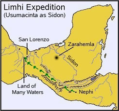
Usumacinta / 시돈강 이제 시돈강은 Usumacinta이며 제이라헤믈라성은 많은 물이 있는 저지대에 있었다는 또 다른 가능성을 고려해 보자. 이것은 Norman의 제안이다. 그러나 그는 그림12에서 보는 바와 같이 제이라헤믈라의 일반적인 지역만을 예시할 뿐으로 커다랗게 흐릿한 지점을 보여 주고 있다. 고고학은 그 지역에서 그 정확한 위치를 찾아 낼 수 있는 사명을 가지고 있다. 그러나 언제 그것이 예고되고 어디서 무엇이 발견될 것인가는 기껏해야 과학의 분야일 뿐이다.
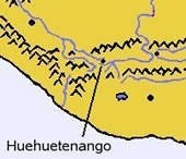
Figure 12. 다시, 화살표는 니파이땅으로부터 데솔레이션땅에 이르는 여행 추정경로를 보여주고 있다. 그 일단의 탐험대는 잘못된 원천지류를 취하여 이제 다른 지역으로는 통과 불능한 협곡에 이르기 까지 Grijalva강을 따라 내려 간 다음 서북방향으로 강을 찾아 나갔다. 이것은 그들이 시돈강이 서북방향으로 흐른다는 것을 알고 있었음을 제언하고 있다. 그러나 그들은 San Lorenzo로 인도되는 강을 발견하였다. 이것은 그당시 파멸된 Olmec(야렛백성)의 성읍이었다. 그것은 그들이 제이라헤믈라가 위치하고 있었다고 알고 있던 많은 물이 있는 땅인 동일한 상태의 낮은 지대와 정확하게 일치하는 개념일 수 있었으니 나파이땅으로부터 예상했던 거리에 있었고 강의 서쪽에 위치했기 때문이다. 이제 그들은 바다에 이르기까지 더 이상 계속하여 나가야 할 필요성이 없었던 것이다. 그 유적들은 좁은 지협에 있었다. 더욱이 그들은 그곳에 Isthmus(지협)이 있다는 사실을 알 필요까지도 없었을 것이다. 다음에 Garth Norman 자실의 말(괄호안에 있는 이름과 숫자는 그의 지도를 말해주고 있다)안에 그 해법이 있다. "그들은 Usumacinta/시돈강과 Grijalva가 서로 만나는 여러 원천이 있는 Huehuetenango (Cumeni,34)의 고지대 계곡에서 출발한다. 그들은 원천지류를 잘못 선택하여 Usumacinta의 원천지류상의 동쪽을 택하는 대신 Grijalva강 북쪽으로 내려간다. 그들이 다른 곳으로 통과하기 불가능한 Samidaro협곡(후일 David Crossing, 35)에 도착했을 때 Chiapas 침하지역을 통하여 서북쪽으로 계속 가다가 Grijalva유역으로 되돌아 가기 위해 Tabasco/바운티풀의 저지대까지 내려가게 된다. 그러나 그들이 시돈강으로 오인한 Rio Coatzacoalcos까지 오게 된다. 그곳에서 그들은 제이라헤믈라라고 보였던 Olmec/야렛백성의 유적을 발견했으니 그것은 남부 베라크루즈/구모라 지구를 통하여 Usumacinta 팔렌퀴 지역 안에 있는 제이라헤믈라의 해안 저지대와 맞먹는다. 그러한 치명적인 과오를 범하게 하는 더 이상의 일련의 환경을 조성하여 주는 곳은 있을 수 없으며 중미에서 몰몬 기록의 진실성에 대하여 더 강력한 지리적 역사적 증거를 찾아낼 수 없다. 나에게 있어서 Norman의 이론은 제이라헤믈라의 유적이 실제로 발견될 때까지 힘찬 설득력이 있는 것이다. 나의 개인적인 전문성은 고고학에 속하지 않고, 대체적으로 퍼즐을 푸는 격이라 할 것이다. 그렇기 때문에 나에게 있어서 이것은 내가 가진 퍼즐에 가장 올바른 해답인 것이다. 제이라헤믈라를 발견하기 위하여 그들에게 주어진 원래의 지시사항은 대강 다음과 같았을 것이다. "Cumeni 부근의 시돈강 원천지류를 찾아내 그것을 따라 많은 물이 있는 저지대에서 강의 서쪽에 있는 큰 성읍에 이르기까지 약 15-20일 쯤 하류로 내려가라" 이것은 그들이 제이라헤믈라로 기대했던 바 San Lorenzo까지 대강 같은 거리로 그들이 내려간 것을 설명하여 주고 있다. 그것은 제이라헤믈라가 위치하고 있는 유사한 저지대의 큰 강 서쪽에서 발견되었다. 그것은 또한 그들이 발견한 많은 물이 있는 땅에 포함된 상세 내용을 설명하여 주기도 한다. 그들은 내려갔던 길을 되돌아 왔을 것이다. 그러므로 귀환 길은 아무런 어려움도 없었을 것이다. 이것은 그 퍼즐에 탁월한 해법같이 보인다. 그러나 이러한 이론이 Norman의 여러 연구내용에서 단 하나의 관점일 뿐이다. 그가 연구한 언어학 분야에 잠시 눈길을 돌려보자. | The Usumacinta as Sidon Now consider the other possibility, that the Sidon was the Usumacinta, and that the city of Zarahemla was in the lowlands, in a the land of many waters. That is Norman's proposal, but he only has the general area of Zarahemla predicted, roughly as shown by the large fuzzy spot in Figure 12 (it actually should be even larger, but that was the biggest my computer could draw). The archaeology remains to be done in that area to discover the exact location, but this is science at its best, when it predicts where something will be found. Again the arrows show the proposed path of the trip from Nephi to Desolation. The party took the wrong tributary and followed the Grijalva river until it comes to an impassible gorge. Then it went northwestward looking for the river, suggesting that they knew that the Sidon flowed in a northwestward direction. Instead, they found the river leading to San Lorenzo, which was at that time a destroyed Olmec (Jaredite) city. It would have been found in exactly the same kind of lowlands and in a land of many waters as they knew Zarahemla was located, and at about the expected distance from Nephi, and on the west side of the river. They would not have even needed to continue on to the sea. Those ruins are in the Narrow Neck, and yet they would not have even needed to know that there was an isthmus there. Here is the solution in Garth Norman's own words (names and numbers in parentheses refers to his map): "They started at the highland valley of Huehuetenango (Cumeni, 34) where the headwaters of the Usumacinta/Sidon and the Grijalva meet. They took the wrong river, traveled north down the Grijalva instead of east on the Usumacinta tributary. When they reached the impassable Sumidaro gorge (later David crossing, 35), they continued northwest thru the Chiapas depression, dropped into the lowlands of Tabasco/Bountiful to get back on the Grijalva, but ended up on the Rio Coatzacoalcos which they mistook for the Sidon. There they found the Olmec/Jaredite ruins westward from San Lorenzo thru the southern Veracruz/Cumorah zone that appeared to them to be Zarahemla. The coastal tropical lowlands in Veracruz matches the coastal lowlands of Zarahemla in the Usumacinta Palenque district. There could not have been a better set of circumstances to make the fatal mistake, and there could hardly be a stronger geographic historic witness for the authenticity of Mormon's record in Mesoamerica."[6] To me, Norman's argument is compelling, pending the actual discovery of the ruins of Zarahemla. My personal expertise is not in archaeology, but rather in puzzle-solving in general, so to me this is the most likely correct answer to the puzzle. Their original instructions to find Zarahemla would have been something like, "Find a tributary of the Sidon near Cumeni and follow it downstream for about 15-20 days until you come to a large city on the west side of the river in a lowland area of many waters." It explains how the trip was about the same distance to San Lorenzo as they had expected to Zarahemla, it was found west of a large river in a similar lowland setting as Zarahemla, and it also explains why the detail that they had found a land of many waters was included. They could have returned by retracing their journey, so there would have been no trouble returning home. This appears to be an excellent solution to the puzzle, but it is only one aspect of Norman's research. Let us turn briefly to his section on linguistics. |
언어학상의 실마리 고고학과 지리적 증거에 더하여, Garth Norman은 자기가 몰몬경의 지정적 위치라고 제안하고 있는 동일한 뜻을 지닌 히브리어나 Nahual어로 추적할 수 있는 어근을 가진 약 20개의 위치를 자신의 연구에 포함하고 있다. 그의 목록에는 히브리어로 Fishery (Tsidon)에 매우 유사한 "Sidon"과 같은 예시를 포함하고 있다. 또한 Usumacinta는 마야의 상형문자에서 Fish River을 뜻한다고 해독하고 있다. 그리고 라모나이 왕이 여어손에 정착했으리라는 지역을 주목하고 있으니 벨리즈에 "Lamani"라 칭하는 고대 마야의 성읍이 있다.
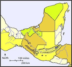
Figure 13. 이것은 나의 전문적인 영역은 아니다. 그러나 그의 주장을 내 자신이 조금이라도 확증할 수 있는 최소한의 언급을 인정하여 주기 바란다. 서로 연관된 이름에 관한 그의 목록은 바운티풀 (그림 13의 멕시코 제주의 지도 참조) 땅이라 그가 믿고 있는 멕시코 주의 "Tabasco"에 대한 제안도 포함하고 있다. 그는 "Tabasco"가 "Bauntiful"을 뜻하는 히브리어와 Nahuatl어의 두 언어에서 기원한다고 제언하고 있다. 이 내용은 일찍이 Meridian Magazine에 기고된 바 있다. 만일 이 내용이 올바르다면 그 발견은 심히 중요한 것 같다. 그것은 마치 고고학자들이 바운티풀땅이 위치하고 있을 것이다라는 실마리를 찾아 Tabascko에 여행하다가 그 지역에 들어서자 그 길가에 "바운티풀행"이라는 안내표지를 발견한 것과 같다. Nahuatl 언어는 나의 지식한계 밖에 있으나 히브리어 구약성서의 강력한 용어색인을 가지고 있어 그의 히브리어 주장을 쉽게 대조하여 볼 수 있다. 영어로 된 "Bountiful"은 구약의 잠언 22:19에 두 번 나타나 있다. 그것은 히브리어 "towb"에서 번역된 것이다. 그리고 이사야 32: 5에는 "showa"에서 번역되어있다. Norman은 Tabasco는 이 두 단어의 조합으로 이루어져 있는 것이라고 제언하고 있다. 나에게 있어서 그는 그 단어의 첫 부분에 그 요체를 잡은 것 같다. Tab"은 더 탐구해 볼 수 있는 가치에 합당하게도 Tabasco에 충분히 근접한 말이다. 그의 언어학적인 발견은 그 자체만으로도 몰몬경의 지리를 결정할 수 있는 매우 중요한 요인임을 증명할 수 있다. 참고로 그림 14는 하나의 지도에서 지리학적이고 정치적인 양대 특징을 함께 보여 주고 있다.
Figure 14. | Linguistic Clues In addition to the archaeological and geographical evidence, Garth Norman has included in his work some twenty locations where the modern names have roots which can be traced to either Hebrew or Nahuatl words of the same meaning as his proposed Book of Mormon locations. His list includes examples like "Sidon" being very similar to the Hebrew word for fishery (Tsidon), and that Usumacinta has been deciphered from a Maya glyph to mean "fish river." He notes that in the area where King Lamoni might have settled in Jershon, there is an ancient Maya city in Belize called "Lamani."
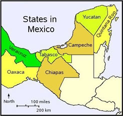
This is not an area of my expertise, but allow me to at least comment on what little I could verify for myself of his claims. His list of correlated names includes the proposal that "Tabasco," the name of the state of Mexico where he believes the land of Bountiful was (see Figure 13 for a map of the states of Mexico). He proposes that "tabasco" comes from both Hebrew and Nahuatl roots meaning "Bountiful," as was reported in an earlier Meridian Magazine article.[7] If correct, that find seems incredibly important. It is as if the archaeologist traveled to Tabasco looking for the clues that it might have been the Land of Bountiful, and as he entered, the sign on the road said, "Entering Bountiful." Nahuatl is beyond my ken, but I have Strong's concordance of the Hebrew Old Testament, and can easily check on his Hebrew claim. The English word "bountiful" appears twice in the Old Testament. In Proverbs 22:9, it is translated from the Hebrew word "towb," and in Isaiah 32:5 it is translated from "showa."[8] Norman suggests that the name Tabasco might be a combination of both words. To me he has won the point just with the first word. "Tob" is close enough to Tabasco to merit further research. His linguistic finds alone could prove to be very important in determining Book of Mormon geography. For reference, Figure 14 shows the geographical and political features together on one map.
|
결론 몰몬경에 기록되어 있는 역사를 서반구 어느 지도상에서 대조하여 보려할 때 남부 멕시코, 콰데말라, 지역은 몰몬경 기록 대부분의 지정적 배치를 지리적, 고고학적, 문화적 및 언어학적으로 탁월하게 일치시킬 수 있음을 발견하게 된다. 대부분의 현대 학자들은 어느 강이 시돈강의 기록과 잘 상관되는지 선택하는 데 있어 의견상의 주요 불일치는 있지만 전반적인 지역에 대해서는 동의하고 있다. 현재는 Grijalva강을 선호하는 경향이 있으나 Garth Norman은 Usumacinta를 선호하는 논리적으로 강력한 이론을 제기하고 있다. 그의 이론은 어찌하여 림하이의 탐험대가 파괴된 야렛인의 성읍을 제이라헤믈라로 오인할 수 있었는가 하는 점을 가장 잘 설명하여 주고 있다. 그러나 최후의 판정은 어느 누가 확실하게 인식하기에 앞서 고고학적인 증거를 기다리지 않으면 안된다. 어느 경우에도 노만은 어느 곳이 많은 사건이 전개되었는가 하는 점을 집어 낼 수 있는 최선의 지도를 구성하여 낸 것 같이 보인다. 그는 언어학적인 증거와 상세한 자료를 더하여 왔다. 이러한 것을 자세하게 검토하여 온 본인의 의견으로는 다른 어떤 시도에서는 이와 같은 지도상의 작업을 더 훌륭하게 하지는 못했다고 생각하고 있다. 몰몬경에서 전개되었던 여러 활동을 따라가 볼 수 있는 하나의 지도를 가졌다는 사실은 그 사건들이 바로 어느 곳에서 발생했는가 하는 것을 시각화 할 수 있음으로 해서 그 사건들을 역동성 있게 하고 또 기억하는데 진정한 도움이 될 수 있다. 번역, 정 민 호 | Conclusion When one tries to fit the history given in the Book of Mormon to a map of the western hemisphere, one finds an excellent match geographically, archaeologically, culturally, and linguistically to the area of southern Mexico and Guatemala as being the setting for most of the record. Most modern scholars have agreed on the general area, with the main difference of opinion being the choice of which river best matches the description of the River Sidon. The current favorite tends to be the Grijalva River, but Garth Norman has made a strong logical argument in favor of the Usumacinta. It best explains how the Limhi expedition could mistake a destroyed Jaredite city for Zarahemla. But the final verdict must await archaeological evidence before one can be certain. In any case, Norman appears to have created the best map to date pinpointing where many events might well have occurred. Moreover, he has added linguistic evidence and detailed references. In the opinion of this reviewer, none of the other attempts at such a map have done so well. Having a map to follow the action can really help bring the story to life and to remember the events by visualizing just where they probably occurred. |
정민호 형제님은 현재 미국에 거주하고 계시며, 교회 회원이 개설한 사이트인 www.koreanlds.org (LDS한인네트워크) 에서 '정민호의 산책'이라는 칼럼에 글을 게재하고 계십니다. 본 글은 정 형제님께서 번역하여 칼럼에 올려 놓으신 글을 옮겨 놓은 것입니다. 정 형제님의 열정과 헌신적인 노력에 감사를 드립니다. | Notes
|


'종교 > 교회사·경전 안내 ' 카테고리의 다른 글
| 연구와 신앙으로 교회사 이해하기 (0) | 2017.02.20 |
|---|---|
| 마틴 해리스가 원고를 분 실했다는 것을 알았을 때 (0) | 2017.02.10 |
| 마틴 손수레 부대 관련 일지 (0) | 2016.05.23 |
| 제1장-첫번째 시현 (0) | 2015.12.29 |
| 제2장-교회의 기초를 세움 (0) | 2015.12.29 |